Please click on any picture for a larger image.
Not the highest pub in Britain, but at almost 1,700 feet, still pretty high - the W800 at the Cat & Fiddle
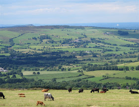
Looking the other way at The Cat, with the Cheshire Plain in the background, the radio telescope at Jodrell Bank prominent near the horizon 2/3 of the way across the picture, left to right
Ashford-in-the-Water, by the Wye bridge (picture taken 11 August on a subsequent ride)
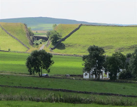
From The Cat we continued to Buxton, Harpur Hill, Brierlow Bar, Taddington, Ashford-in-the-Water, Sheldon (past Magpie Mine), to Monyash. Beyond Monyash we took 'The Rake' which just before it joins the Buxton - Ashbourne road affords this splendid view of the cutting south of Parsley Hay on the long extinct Buxton to Ashbourne railway
Here's a closer look at the cutting. The railway from Buxton to Parsley Hay utilised the (modified) trackbed of the 1831 Cromford & High Peak Railway. That railway was built rather like a canal, with flat sections joined by inclined planes with cable haulage by stationary steam engines being the equivalent of a flight of locks, and the section of the C&HPR from Parsley Hay to Cromford survived in its original form until closure in the 1960s. Today it forms the High Peak Trail, a walking and cycling way. The section of 1899 the Buxton to Ashbourne railway line from Parsley Hay southwards was newly constructed in 1899. In this picture Parsley Hay is off the picture to the right, the C&HPR to Cromford (now the High Peak Trail) follows the dry stone wall across the middle of the picture where it exits on its way to Cromford, right to left, while the 1899 line to Ashbourne (now the Tissington Trail) ran through the cutting on its way to that town.
The village pond in Hartington
From Hartington we took the lovely high road on the ridge top between the valleys of the Manifold and the Dove. The land falls away to the Dove on the right (above) and to the Manifold on the left.
Coming off the end of the ridge, above Longnor. The 'Dragon's Back' hills are in the background
At Glutton Bridge, beside the Dragon's Back hills; Parkhouse Hill to the right of the bike, Chrome hill behind it. These two distinctive razor-back hills are former coral reef formations and were off limits to walkers until the 'right to roam' opened up access. They make an interesting if challenging scramble, especially in wet weather when the grass and the exposed limestone are slippery!
Time for a pie and a pint at 'The Quiet Woman', in Earl Sterndale. The pub's sign depicts a headless woman! The lunch menu is somewhat limited - pork pie or... pork pie. These used to be very good last time I was here, but at the time of this visit were typical 'supermarket' pies; cellophane wrapped, bland and tasteless, with soggy pastry. But the beer was still good!
From Earl Sterndale we headed south back to Longnor, then west to Royal Cottage by the Winking Man, then south east up onto the ancient ridgeway, past the old 'Mermaid Inn', overlooking The Roaches (visible in the background, above). Click on the picture to enlarge it and you can clearly see the old GPO radio tower on the horizon, on Croker Hill near Bosley.

Mermaid Pool, above Upper Hulme (picture taken 11 August on a subsequent ride)

Mermaid Pool, above Upper Hulme (picture taken 11 August on a subsequent ride)
Looking down from the ridge Jodrell Bank radio telescope can again be seen on the Cheshire Plain, with the long escarpment of Bosley Cloud on the left horizon
In the near distance, the Pecforton Hills in West Cheshire with the distinctive Beeston Hill at the righthand extremity of the range. In the background are the Welsh mountains.
Visibility was excellent today and once again Jodrell Bank is clearly visible. Click on the picture for a larger image and the cooling towers of Fiddlers Ferry power station near Warrington are just visible on the horizon.
Dropping down off the ridge we crossed the Buxton to Leek road and passed the end of Tittesworth Reservoir, looking very low, to Rushton Spencer and on up onto the ridge between Biddulph and Rudyard Lake. Here's the view north from there including again the Former GPO radio tower on Croker Hill, seen from a different direction. This tower used to be adorned with distinctive microwave waveguide horns, but these have been removed making look a bit 'sparse' as an almost naked concrete column (it does still carry some communications antennae). It's a pity they couldn't have left the horns on to retain the tower's characteristic shape. These days of course the data that used to be transmitted by microwave radio links goes by underground fibre optic cable, which has a far higher bandwidth so can carry more information.
Looking back the other way the ridge leading up to Mow Cop was visible
From this ridge (which is on one of my regular routes to Rudyard and the Churnet Valley) we dropped down into Congleton and back home along the A34.
The W800 is a great bike for a ride out like this; easy to ride, relatively light to manoeuvre comfortable with its upright riding position, good handling, and fast enough for grabbing overtaking opportunities without drama. It thrumbs along with an engine and exhaust note not unlike that earlier parallel twin I used to own, the old Triumph Bonneville. It really is a modern version of that bike, but without the oil leaks, maintenance overhead, and unreliability. The hundred miles I did on it today bring its mileage so far up to about 270. Soon be ready for its first service!
The W800 is a great bike for a ride out like this; easy to ride, relatively light to manoeuvre comfortable with its upright riding position, good handling, and fast enough for grabbing overtaking opportunities without drama. It thrumbs along with an engine and exhaust note not unlike that earlier parallel twin I used to own, the old Triumph Bonneville. It really is a modern version of that bike, but without the oil leaks, maintenance overhead, and unreliability. The hundred miles I did on it today bring its mileage so far up to about 270. Soon be ready for its first service!
.


Lovely. Makes me want to go back, do my CBT again, Direct Access and then get myself a bike!
ReplyDeleteThat's what I did, Dan, many years ago. Thanks for the kind comment.
ReplyDeleteCheers
Vince